
In Malaysia’s evolving real estate and construction landscape, precision, traceability, and accountability are no longer optional — they are essential. Traditional dilapidation surveys using tape, sketches, and photos fall short when dealing with complex buildings, tighter tolerances, and legal scrutiny.
That’s why digital dilapidation survey—leveraging LiDAR scanning plus 360° photography—is disrupting how building condition assessments are done. And we are proud to be the first company in Malaysia to pilot test this advanced method in the property inspection domain.
In this post, we compare traditional vs digital methods, explore the latest technology, describe our pilot test, share use‑cases (including a shoplot in Klang), and lay out best practices and future directions.
Table of Contents
- The Limitations of Traditional Dilapidation Survey
- What Is a Digital Dilapidation Survey (LiDAR + 360° Imaging)
- Key Differences: Traditional vs Digital
- Recent Technological Advances
- Our Malaysia Pilot: Shoplot in Klang
- Workflow of a Digital Dilapidation Survey
- Benefits & Challenges
- Use Cases & Applications in Malaysia
- Best Practices, Standards & Future Trends
- Contact Us
- Conclusion & FAQs
1. The Limitations of Traditional Dilapidation Survey
Traditional dilapidation surveys often rely on manual measurements (tape, laser distance meters), visual inspections, sketches, and photographs. While still widely used, these methods face several challenges:
- Time consumption: Walking through lengthy corridors, façades, and interiors, measuring point by point, and documenting defects is laborious.
- Human error: Misreading tapes, missing points, inconsistent photo framing, or illegible notes introduce risk.
- Inadequate documentation: Some micro‑cracks, slight floor tilt, or surface warping may go unnoticed.
- Difficulty in revisiting or comparing: Later inspections often can’t map exactly to earlier measurement points.
- Subjectivity: One inspector’s judgment of “minor crack” may differ from another’s.
These deficiencies become especially problematic when disputes, insurance claims, or structural integrity over time are at stake. That’s where digital dilapidation survey offers a superior, next‑generation alternative.
2. What Is a Digital Dilapidation Survey (LiDAR + 360° Imaging)
A digital dilapidation survey is a condition assessment method that fuses high-resolution 3D geometry (via LiDAR scanning) with immersive visual context (via 360° photography). The end result is a rich, interactive, and objective record of existing building conditions — inside and out.
Key components:
- LiDAR (Light Detection and Ranging): Captures spatial geometry by emitting laser pulses and measuring return time, creating dense point clouds of XYZ coordinates.
- 360° / panoramic imaging: Captures full spherical (or near-spherical) visual context (color, texture) that can be aligned (registered) with the LiDAR point cloud.
- Colorized Point Cloud: By aligning imagery and geometry, each point in the cloud can carry RGB color information, aiding visual diagnosis.
- Change‑detection & temporal analysis: Because scans can be registered to the same coordinate frame over time, deviations or defects that develop can be quantified precisely.
This hybrid method mitigates the weaknesses of each modality when used alone: LiDAR alone lacks visual richness; 360° imagery alone lacks depth measurement.
3. Key Differences: Traditional vs Digital
| Aspect | Traditional Dilapidation Survey | Digital Dilapidation Survey |
|---|---|---|
| Accuracy & Detail | Limited to manual points and visible cracks | Dense point clouds can reveal micro defects, subtle warps |
| Speed & Productivity | Slow; many man-hours | Faster scanning, less repeated site time |
| Repeatability | Hard to exactly revisit same points | Registration ensures the same geometry reference over time |
| Visualization | 2D photos and sketches | Immersive 3D models, fly‑throughs, virtual inspection |
| Change Detection | Manual comparison of photos | Automated or semi-automated spatial comparison |
| Risk & Accessibility | High risk in tight, high, or unsafe areas | Remote scanning reduces risk to personnel |
| Subjectivity | Depends heavily on inspector judgment | More objective measurement and defect scoring |
| Upfront Investment | Low (tools are basic) | Higher hardware/software cost, but lower labor over time |
Technical literature and surveying practice support that combining LiDAR and panoramic imaging yields the most robust results for building condition assessments.
4. Recent Technological Advances
To push digital dilapidation survey into practical adoption, several tech advances are enabling better performance and usability:
- Handheld & SLAM-based LiDAR systems: Allow scanning without fixed tripods or prisms, especially in interiors or tight zones.
- Hybrid depth-augmented SLAM (e.g. HDPV‑SLAM): Combines LiDAR plus panoramic vision to densify sparse depth and deliver accurate trajectory mapping.
- Improved colorization & registration algorithms: Better alignment between imagery and point clouds, fewer ghosting artifacts, enhanced visual fidelity.
- Real-time quality monitoring: On-site previews allow scanning crews to discover gaps or alignment issues and re-scan immediately.
- AI / defect detection modules: Automated crack detection, surface deviation analysis, and defect severity scoring based on the 3D + imagery data.
- Cloud / Web 3D viewers: Stakeholders can remotely explore the point cloud in browser-based viewers, annotate, measure, and compare epochs.
- Data fusion (drone + terrestrial): Exterior façades or roofs captured via drone LiDAR or photogrammetry fused with ground-level scans for comprehensive coverage.
- Better edge / local processing: More efficient data compression, on-device preprocessing, and adaptive filtering reduce back-office burdens.
All these advances lower barriers to adoption, reduce error, and improve stakeholder usability.
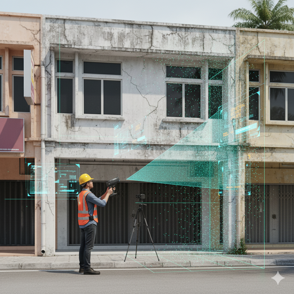
5. Our Malaysia Pilot: Shoplot in Klang
To bring theory into practice, Pro Inspect Solution embarked on Malaysia’s first pilot test combining LiDAR scanning and 360° photography for a digital dilapidation survey of a shoplot in Klang, Selangor.
Pilot Overview
- Property: Two-storey shoplot
- Scope: Exterior façade, roof slab, stairwells, corridors, internal walls, ceiling finishes
- Hardware & Tools: SLAM-based LiDAR scanner, 360° panoramic camera rig, control markers, calibration tools
- Timeline: 1.5 days of field scanning; 2 days of processing, QA, and reporting
- Deliverables:
- Colored point cloud model
- Annotated defect map (cracks, warps, deformations)
- Interactive web-based walkthrough viewer
- Detailed digital dilapidation survey report (PDF + visuals + measurements)
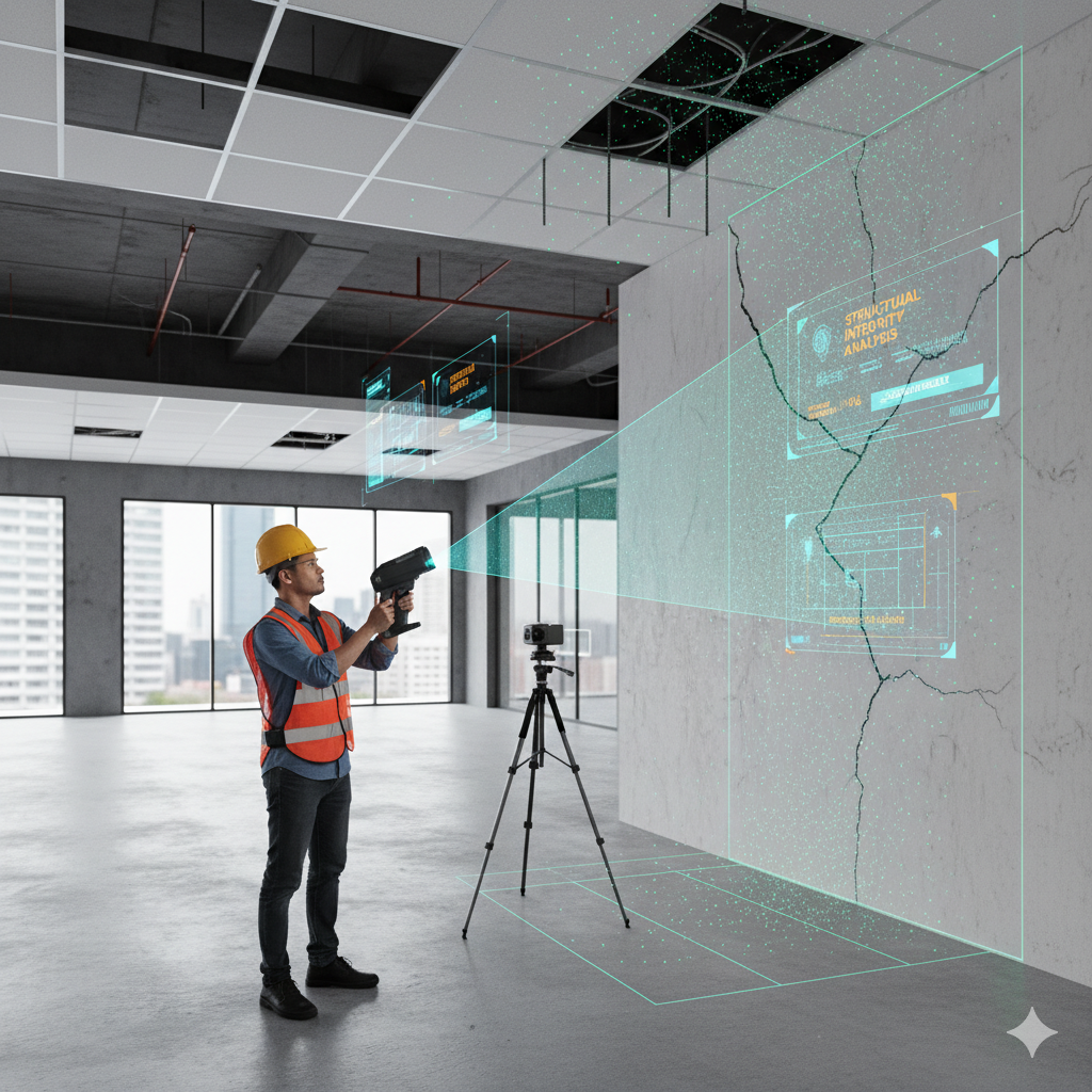
Results & Key Takeaways
- Significant time saving: Field survey time reduced by over 60% compared to traditional methods for the same scope.
- High-resolution detection: We discovered fine hairline cracks (< 1 mm) and floor tilt deviations within a ±5 mm envelope.
- Remote stakeholder access: Clients and engineers could inspect critical zones online without returning to site.
- Solid documentation: The detailed 3D record served as a comprehensive baseline — ideal for future comparison or claims.
This pilot test validated that digital dilapidation survey is not just feasible in Malaysia but adds real value in speed, accuracy, and stakeholder confidence.
6. Workflow of a Digital Dilapidation Survey
A standard workflow for conducting a digital dilapidation survey might include:
- Planning & Pre‑survey
- Review architectural drawings and site constraints
- Identify known defect-prone zones (façades, expansion joints, parapets)
- Plan scanning stations, overlaps, and control marker placement
- Field Scanning & Imaging
- Deploy LiDAR scans at stations (interior, exterior)
- Capture 360° panoramas at each station
- Use overlapping loops and closure scans to reduce drift
- For façades or inaccessible zones, deploy drone LiDAR or photogrammetry
- Registration & Alignment
- Register all LiDAR scans via control markers or tie points
- Align 360° images to the point cloud to colorize geometry
- Fuse aerial + terrestrial data into unified coordinate frame
- Post‑Processing & Clean Up
- Filter noise, remove outliers, denoise reflective surfaces
- Inspect for alignment gaps, rescan if necessary
- Segment structural elements for analysis
- Defect & Change Analysis
- Detect cracks, offsets, dents, spalling, warpage
- Annotate severity and location
- If prior scans exist, perform change detection
- Deliverables & Visualization
- Export colored point cloud (LAS, E57, PLY)
- Provide web / cloud 3D viewer with navigation, annotations, measurement
- Supply digital dilapidation survey report with visuals, annotated maps, measurement tables
- Archival & Future Monitoring
- Store raw and processed data for future re‑analysis
- Schedule periodic re‑scans to monitor structural drift or deterioration
7. Benefits & Challenges
Benefits of Digital Dilapidation Survey
- High precision & repeatability: Millimeter-level geometry, exact revisit capability
- Time & cost efficiency (long-term): Faster surveys, fewer site revisits
- Better stakeholder collaboration: Remote access, annotation, review
- Legal robustness: Comprehensive digital records help mitigate disputes
- Ongoing monitoring: Trend detection, movement mapping, maintenance forecasting
- Integration potential: Feeding data into BIM, digital twin, asset management
Challenges & Mitigation
| Challenge | Mitigation Strategy |
|---|---|
| High upfront investment | Begin with pilot projects, amortize across multiple jobs |
| Large data volume & computing load | Use optimized compression, cloud processing, and progressive streaming |
| Reflective / transparent surfaces noise | Apply multi-angle scanning, surface smoothing, and masking |
| Drift / misalignment errors | Use sufficient overlap, control markers, loop closures |
| Insufficient local standards | Adopt international best practices and document QA procedures |
| Resistance to adoption | Demonstrate ROI, show pilot successes like our Klang shoplot project |
8. Use Cases & Applications in Malaysia
8.1 Pilot Test by Pro Inspect Solution: Shoplot in Klang
Our pilot test on a shoplot in Klang stands as Malaysia’s first successful digital dilapidation survey deployment. Through this project, we proved that digital dilapidation survey is practical, valuable, and ready for scale in local contexts. The lessons learned and outcome confidence form the foundation for broader application across Malaysia.
8.2 Where Else Digital Dilapidation Survey Can Be Used
Following the success in Klang, here are additional property and infrastructure types in Malaysia that can benefit:
- Commercial properties (offices, retail malls, mixed-use buildings)
- Strata residential developments (condominiums, apartments, gated communities)
- Pre- & post-construction surveys (especially adjacent to excavation, piling, or demolition)
- Heritage & conservation buildings (colonial era shophouses, cultural assets)
- Hotels & hospitality sites
- Educational institutions (schools, lecture halls, dormitories)
- Industrial warehouses & factories
- Government buildings, community halls, public infrastructure
- Lease handover and tenant handover cases (to document condition baseline for dispute avoidance)
Given Malaysia’s rapid development, many building owners, developers, and facility managers will find clear ROI in adopting digital dilapidation survey as a standard practice.
9. Best Practices, Standards & Future Trends
Best Practices
- Ensure sufficient overlap and redundancy in scanning
- Use fiducial control markers for georeferencing
- Calibrate imaging rigs and LiDAR scanners regularly
- Apply HDR imaging techniques and consistent lighting
- Perform real-time QA in the field to detect missing scans
- Archive raw data and metadata (scanner settings, time, location)
- Train staff continuously in new scanning & processing methods
Standards & Protocols
- Follow international guidelines (ASTM, ASCE, RICS) for 3D scanning in structural inspection
- Use BIM / IFC / COBie for as-built model integration
- Adopt QA tolerances in registration error, point density, alignment
Future Trends
- Stronger AI / vision integration: real-time defect detection
- Cheaper, lighter scanning hardware for mass adoption
- Edge computing and pre‑processing on scanning rigs
- Web / mobile-first 3D model access and annotation
- Regulatory acceptance: digital scan records as legal baseline
- Tighter linkage to digital twin, asset management, predictive maintenance
10. Contact Us
If you’re interested in leveraging digital dilapidation survey for your building, development, or facility, Pro Inspect Solution is ready to help. We combine cutting-edge LiDAR + 360° imaging with engineering insight to deliver precise and defensible condition assessments.
Contact Information:
Pro Inspect Solution Sdn Bhd
+60 16‑806 4902
inspectsolution.pro@gmail.com
11‑2, Jalan PJS 8/11, Dataran Mentari,
46150 Petaling Jaya, Selangor, Malaysia
Website: inspectsolution.pro (Inspect Solution)
We welcome you to reach out for consultation, pilot test proposals, or quoting your next project. Let us help you define the future of building inspections with digital precision.
11. Conclusion & FAQs
Conclusion
The shift from traditional dilapidation survey methods to a digital dilapidation survey approach is not just a tech trend — it’s a necessary evolution for Malaysia’s built environment. With LiDAR scanning, 360° imaging, and advanced data processing, property owners, developers, and facility managers gain unmatched precision, auditability, and insight into structural condition.
Our pilot test on a shoplot in Klang demonstrates that this technology is deployable today, not just in theoretical terms. We are proud to have led Malaysia’s first such deployment and stand ready to scale this across diverse building types and infrastructure projects.
FAQs
Q1. What is the accuracy of a digital dilapidation survey?
It depends on the hardware, calibration, overlap, and data processing. In our pilot, we achieved detection and measurement within ±5 mm tolerances.
Q2. How much does it cost compared to traditional surveys?
The upfront cost is higher due to LiDAR and imaging equipment. But labor, rework, and repeated site visits drop significantly, making the long-term cost per project often lower — especially for larger or repeating assets.
Q3. Can the survey be done while property is occupied?
Yes. However, moving objects (furniture, people) should be minimized or removed during key scans. Dynamic elements can often be filtered out in post-processing.
Q4. How often should such surveys be repeated?
Depending on building type and condition, a schedule of every 3–5 years is common, or after significant events (earthquakes, renovation, structural stress).
Q5. Will courts, insurers, or regulators accept these digital records?
Adoption is still emerging in Malaysia. However, the high fidelity, timestamping, and objective nature of digital dilapidation survey data make it increasingly persuasive as legal evidence. Proper documentation, QA, and adherence to recognized practices strengthen acceptability.
Q6. What if parts of the building (roof, façade) are inaccessible from the ground?
We integrate drone LiDAR or photogrammetry to fill gaps, then fuse that with terrestrial scans for a seamless model.
 (3)")