
The Malaysian construction and property sector is standing on the brink of a digital revolution. With the highly anticipated Malaysia Building Information Modelling (BIM) Mandate set to take full effect by 2026, industry standards are shifting rapidly. Initiated by the Construction Industry Development Board (CIDB Malaysia) and the Public Works Department (JKR), this mandate requires government and major private projects to adopt BIM technologies. For property owners, developers, and contractors, transitioning to this digital-first approach requires the right tools—and at the forefront of this transition is 3D LiDAR Scanning.
In this comprehensive guide by Pro Inspect Solution, we explore how cutting-edge laser scanning technology acts as the essential bridge between physical structures and digital twins, and why adopting it now is critical for regulatory compliance, cost-efficiency, and future-proofing your assets.
Understanding the Malaysia BIM Mandate 2026
The Malaysian government has recognized that traditional construction and facility management methods often lead to cost overruns, timeline delays, and extensive material waste. The upcoming BIM mandate aims to mitigate these issues by requiring digital representations of physical and functional characteristics of places. This shift ensures better collaboration across all disciplines—from architectural and structural engineering to plumbing and electrical installations.
However, you cannot create an accurate digital model of an existing building without precise measurements. This is where modern spatial data capturing becomes non-negotiable, acting as the foundational layer for any reliable BIM workflow.
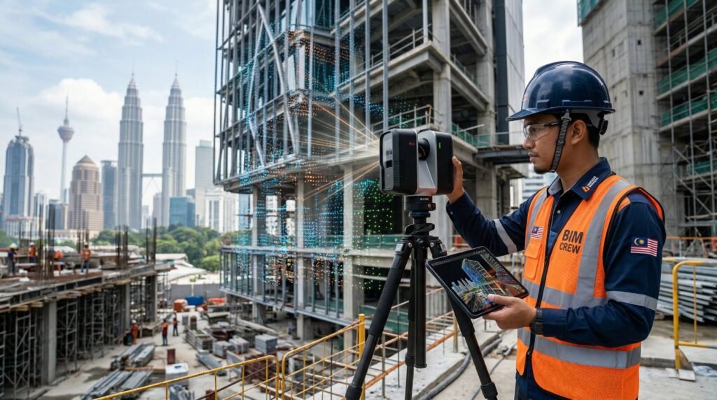
What is 3D LiDAR Scanning and Why Does it Matter?
LiDAR (Light Detection and Ranging) is a remote sensing method that uses light in the form of a pulsed laser to measure variable distances to the Earth or specific structures. When applied to buildings, a 3D LiDAR scanner captures millions of data points per second, creating a highly detailed and millimeter-accurate “point cloud” of a physical space.

When conducting an as-built survey Malaysia, traditional methods using tape measures or basic laser distance meters are prone to human error and are immensely time-consuming. 3D LiDAR Scanning mitigates these risks by capturing complex geometries, mechanical, electrical, and plumbing (MEP) systems, and structural deformations with absolute precision. This level of accuracy is highly beneficial when preparing a dilapidation survey for neighboring properties prior to major construction.
The Crucial Role of LiDAR in Scan-to-BIM Services
One of the primary applications of 3D LiDAR Scanning in the wake of the 2026 mandate is the enablement of Scan-to-BIM services. This process involves translating the dense, raw point cloud data captured by the scanner into a highly detailed, intelligent 3D BIM model (typically using software like Autodesk Revit).
Benefits of Scan-to-BIM for Existing Structures
- Clash Detection: By modeling the exact existing conditions, contractors can identify clashes between new designs and existing structural elements before construction begins.
- Historic Preservation: Accurately digitally preserving heritage buildings in Malaysia without invasive measuring techniques.
- Dispute Prevention: Having an indisputable digital record of a site’s condition is invaluable. In fact, accurate spatial data is often requested during expert witness and dispute resolution cases to resolve contractor and developer conflicts.
From Point Clouds to Precise 2D AutoCAD Floor Plans
While BIM represents the future, the reality of the Malaysian construction industry is that many local councils, sub-contractors, and property managers still heavily rely on traditional 2D documentation. Fortunately, 3D LiDAR Scanning bridges the gap between the future and the present.

The point cloud data can be “sliced” at any elevation to extract perfectly accurate 2D AutoCAD floor plans, elevation drawings, and cross-sections. This is a core component of our As-Built Survey & Drawing Services. Whether you need structural layouts for an extension or detailed architectural plans for interior design, LiDAR ensures that your 2D drawings are a flawless reflection of reality, entirely eliminating the “assumed dimensions” that cause costly downstream errors.
Enhancing Facility Management BIM with Accurate Data
BIM is not just for the construction phase; its true long-term value lies in facility management. Facility management BIM (often referred to as 6D or 7D BIM) integrates asset data, maintenance schedules, and warranty information directly into the 3D model.
By conducting a 3D LiDAR scan, property managers obtain a precise “Digital Twin” of their building. This allows for highly effective building condition assessments. Furthermore, combining interior LiDAR data with exterior façade & roof inspections using drones provides a complete, 360-degree digital mapping of high-rise properties, allowing facility managers to track structural health and schedule maintenance efficiently.
Navigating Renovation Submission Guidelines Seamlessly
In Malaysia, submitting plans for building renovations to local authorities (Pihak Berkuasa Tempatan or PBT) requires strict adherence to renovation submission guidelines. Submitting inaccurate as-built drawings is one of the leading causes of permit rejections, leading to project delays and holding costs.
By utilizing 3D LiDAR scanning to generate your existing floor plans, you guarantee that your submissions meet the stringent accuracy requirements of local municipal councils. When you pair this with mandatory periodic building inspections, you ensure that your property not only meets the legal submission criteria but remains safe, compliant, and structurally sound for years to come.
Frequently Asked Questions (FAQ)
What is the Malaysia BIM Mandate 2026?
The Malaysia BIM Mandate 2026 is a directive by the government, spearheaded by CIDB and JKR, requiring the mandatory adoption of Building Information Modelling (BIM) for government and major private construction projects to improve efficiency, accuracy, and project lifecycle management.
How does 3D LiDAR Scanning improve as-built surveys in Malaysia?
3D LiDAR Scanning uses laser technology to capture millions of data points, creating a highly accurate 3D point cloud of a building. This eliminates manual measurement errors, significantly speeds up the surveying process, and captures complex architectural and MEP details that traditional methods often miss.
Are Scan-to-BIM services necessary for older or heritage buildings?
Yes. Scan-to-BIM services are highly recommended for older or heritage buildings because original blueprints are often missing or inaccurate due to decades of unrecorded modifications. LiDAR scanning provides a non-invasive way to digitally capture and preserve the exact current state of the building.
Can 3D LiDAR data be converted into standard 2D AutoCAD floor plans?
Absolutely. The dense point cloud data captured by LiDAR can be sectioned at any height or angle to draft highly precise 2D AutoCAD floor plans, elevation views, and cross-sections, which are essential for standard renovation submissions to local Malaysian authorities.
Ready for the BIM Mandate? Upgrade Your As-Built Surveys Today
Don’t let inaccurate drawings delay your project or cause compliance issues. Leverage our professional 3D LiDAR Scanning and Scan-to-BIM services to ensure absolute precision for your next development.
 (3)")