
By Ir Vimal | Kuala Lumpur, Malaysia — April 28, 2026
In the fiercely competitive Malaysian property market, budget overruns are a nightmare that developers and property owners actively dread. With unpredictable supply chain disruptions and shifting labor rates dominating industry headlines in 2026, mitigating financial risk is no longer optional—it is a critical necessity. Enter 3D LiDAR Scanning, a transformative technology that is rapidly redefining how we approach building, maintaining, and upgrading properties in Malaysia.
Whether you are a developer spearheading a commercial high-rise in Kuala Lumpur, or a homeowner embarking on ambitious renovation projects in Penang, the accuracy of your building data dictates your bottom line. But can adopting this advanced laser scanning technology truly protect your investment from spiraling out of control? Let’s dive deep into how precision data collection is saving Malaysians millions in avoidable construction costs.
The Reality of Rising Construction Costs in Malaysia
Anyone involved in the local property sector knows that rising construction costs Malaysia is more than just a trending buzzword; it is a harsh reality. According to recent reports from the Construction Industry Development Board (CIDB) Malaysia and ongoing coverage by major local business publications, fluctuating building material prices (like steel and cement) coupled with persistent foreign labor shortages have squeezed profit margins tight.
When materials are expensive, you cannot afford to measure twice and cut three times. Rework—often caused by inaccurate initial measurements, outdated floor plans, or unseen structural anomalies—accounts for an estimated 5% to 12% of total project costs in traditional construction workflows. In today’s economy, eliminating that margin of error is where technology steps in to save the day.
What Exactly is 3D LiDAR Scanning?
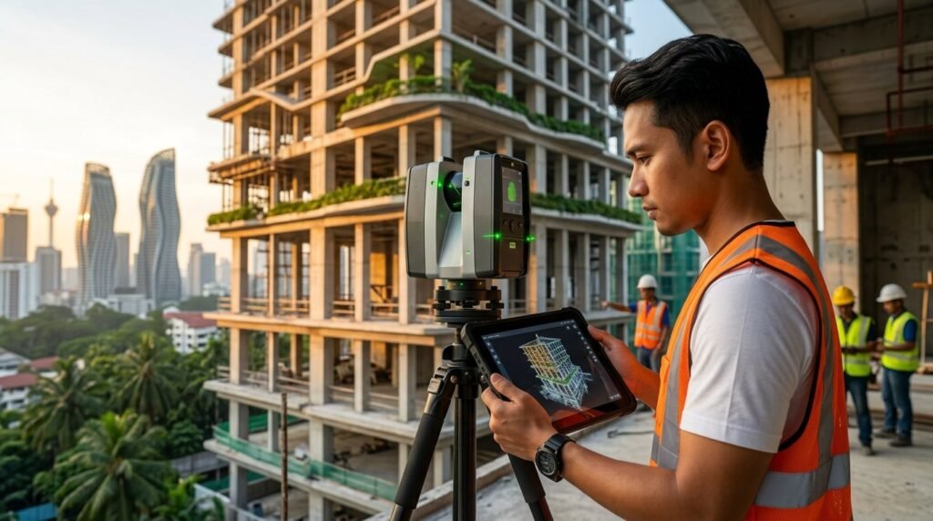
LiDAR, which stands for Light Detection and Ranging, is a remote sensing method that uses pulsed laser light to measure distances with millimeter-level accuracy. When used in building inspection and surveying, a 3D LiDAR scanner rotates at high speeds, sending out millions of laser pulses per second. These pulses bounce off surrounding surfaces—walls, pipes, structural beams, and architectural details—and return to the sensor.

The result is a highly detailed “Point Cloud”—a precise 3D digital replica (or digital twin) of the physical space. For property developers and contractors aiming for high QLASSIC (Quality Assessment System in Construction) scores, having this indisputable, high-fidelity data from day one is an absolute game-changer.
How 3D LiDAR Scanning Shields You from Budget Blowouts
Investing in 3D LiDAR Scanning might seem like an upfront premium, but the return on investment (ROI) becomes glaringly obvious once the project commences. Here is how this technology acts as your financial safeguard.
1. Creating Flawless As-Built Survey Drawings
One of the most common pitfalls in property upgrades is relying on old, inaccurate blueprints. Buildings settle, undocumented modifications happen, and initial design drawings rarely reflect reality perfectly. By utilizing an accurate as-built survey drawing generated from a LiDAR scan, architects and engineers can work with exact, current measurements.
At Pro Inspect Solution, we emphasize that having a perfect as-built drawing prevents scenarios where custom-fabricated materials arrive on site, only to not fit the actual space—saving tens of thousands of Ringgit in wasted materials and project delays.
2. De-risking Complex Renovation Projects
Renovation projects in Malaysia, particularly those involving adaptive reuse of heritage buildings in places like Melaka or Georgetown, carry immense hidden risks. Walls may not be perfectly plumb, and floors may be uneven. 3D LiDAR scanning captures these imperfections in stunning detail before a single hammer is swung.
By identifying structural sagging or alignment issues early, contractors can adjust their approach, avoiding mid-construction crises. If structural anomalies are detected during the scanning phase, property owners can seamlessly consult experts for structural repair consultancy to address the issues proactively rather than reactively.
3. Unlocking Advanced BIM Capabilities
The Malaysian government has been strongly advocating for the adoption of Building Information Modelling (BIM) for public and large-scale private projects. 3D LiDAR scanning supercharges your BIM capabilities through a process known as “Scan-to-BIM.”
The point cloud data is imported directly into BIM software (like Revit or ArchiCAD) to create a parametric, intelligent 3D model. This allows for superior clash detection (e.g., ensuring a new HVAC duct won’t intersect with an existing structural beam) long before construction begins. Improved BIM capabilities mean a smoother workflow, better cross-department collaboration, and zero “surprise” costs on site.
Integrating LiDAR with Professional Building Inspections
While 3D LiDAR Scanning is a powerful standalone tool, its true value is unlocked when integrated with comprehensive property inspections. For developers handing over new projects, pairing laser scanning with comprehensive building condition assessments ensures complete transparency and accountability.

Consider these synergy scenarios:
- Pre-Construction: Before starting heavy piling works next to an existing structure, contractors can utilize LiDAR alongside pre-construction dilapidation surveys to document the exact condition of neighboring properties, protecting against fraudulent damage claims.
- Maintenance: For high-rise commercial buildings, LiDAR can be combined with drone-assisted façade & roof inspections to create a complete exterior and interior digital twin.
- Compliance: When conducting mandatory Pemeriksaan Bangunan Berkala (Periodic Inspections) required by local authorities, precise 3D data provides an indisputable baseline of structural health.
- Legal Disputes: If a project goes awry and you require expert witness and dispute resolution services, having millimeter-accurate, time-stamped 3D scan data serves as undeniable evidence in a court of law or arbitration in Malaysia.
Frequently Asked Questions (FAQ)
Is 3D LiDAR Scanning worth the investment for small renovation projects?
Yes. While initially seen as an enterprise-level tool, 3D LiDAR scanning pays for itself in small to medium renovation projects by preventing costly material wastage and rework, which is crucial given the rising construction costs in Malaysia.
How does an as-built survey drawing from a LiDAR scan differ from traditional methods?
Traditional surveys rely on manual measurements which are prone to human error and blind spots. A 3D LiDAR scanner captures millions of data points per second to create a millimeter-accurate digital twin, ensuring your as-built survey drawing is flawlessly precise.
Can LiDAR scans integrate with my architect’s BIM software?
Absolutely. The point cloud data generated from 3D LiDAR Scanning seamlessly imports into major BIM (Building Information Modeling) platforms like Revit and AutoCAD, enhancing overall BIM capabilities for developers and architects.
Don’t Let Bad Data Drain Your Construction Budget
In an era of tight margins and rising construction costs in Malaysia, guesswork is the most expensive mistake you can make. By harnessing 3D LiDAR Scanning for your next project, you guarantee precision, efficiency, and peace of mind. Whether you require an accurate as-built survey drawing or want to elevate your project’s BIM capabilities, taking the technological leap is your best defense against budget blowouts.
 (3)")